
Columbia, SC (WLTX) — Hurricane Florence got slightly weaker Wednesday, but that's no comfort: the storm will still be one of the stronger storms in the history of the East Coast when it moves ashore along the Carolinas.
If the current track holds up, it looks as it the state of South Carolina will see significant impacts from the storm for several days. At this point, people in the state should begin making their hurricane preparations.
However, there is still some uncertainty, so it's still too early to pinpoint the storm's exact effects on each specific community.. With that said, here's the latest on where the storm is now, and the current thinking on what it might do next.
Tropical Storm Florence: Latest Conditions
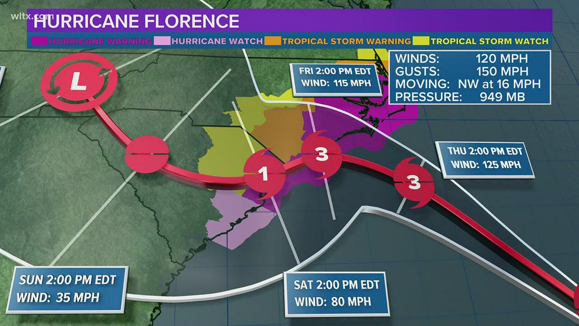
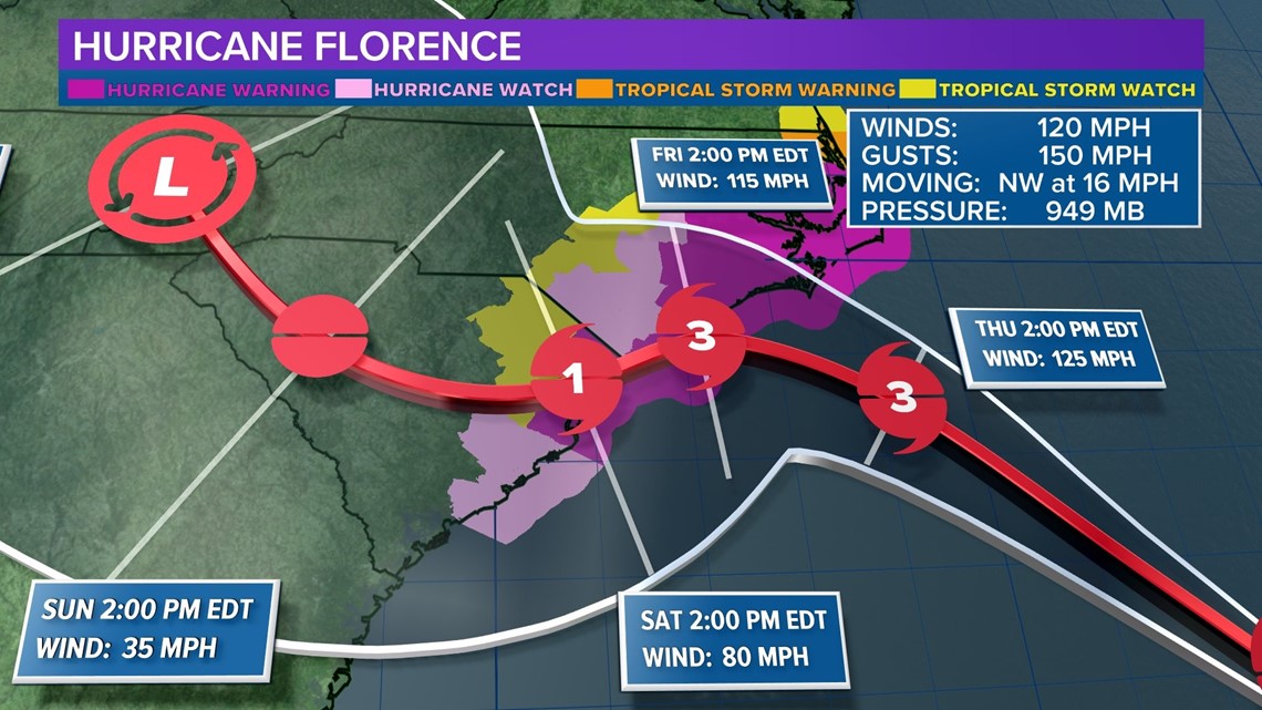
Florence remains a Category 3 hurricane. As of the 5 PM Wednesday advisory from the National Hurricane Center, maximum sustained are near 120 MPH with higher gusts and is moving toward the west-northwest at near 15 mph. That's down from the 130 MPH wind earlier today.
The storm is expected to increase in physical size as it moves closer to the shore.
Latest Models/Tracks: Where is Florence Headed?
The current consensus model track from the National Hurricane Center is pretty consistently showing a landfall in the Carolinas. The model runs have been showing with that for several days, and that's not changing.
But what's changed it the timing and the overall track. The current consensus track has the storm now making landfall in Horry County sometime Saturday, the pushing inland. The center of circulation would then push across the center of the state over Saturday and Sunday. The Midlands would be in the heart of this path.
What exact impacts could we see? It's hard to tell exactly, but depending on the track, and if it shifts, will greatly affect that. We've also got to see how much the storm weakens as it moves over lane.
It is important to realize that significant impacts extend well away from the center of Florence, and serious hazards such as a dangerous storm surge and flooding rains will cover a large area regardless of exactly where the center moves.
You can see the basic path on the track released by the National Hurricane Center.
Latest National Hurricane Center Track

Whereas a day or two ago the so-called 'spaghetti plots' were in good agreement, they differ a good bit now after landfall. But nearly all are tracking across South Carolina
So where exactly will it go? We're sorry to say, but at this point, we can't give a definitive answer. Bottom line: everyone should be monitoring and preparing.
Florence Latest Spaghetti Models

Other impacts? But then comes the rain. The storm will essentially park itself over the area., the slowly--and we do mean slowly--move inland. Because it doesn't have a lot of speed behind it, the rainfall will be extensive. Some areas will see heavy, if not historic flooding.
This may be similar to what Hurricane Matthew did to eastern North Carolina just two years ago, and Hurricane Harvey did in Texas last year.
Timing: When Will Hurricane Florence Strike?
Florence is moving over the southwestern Atlantic Ocean between Bermuda and the Bahamas today, and is expected to approach the coast of North Carolina or South Carolina in the hurricane
warning area on Friday.
Florence is expected to start bringing tropical storm force winds to the Carolinas late Thursday. Landfall could take place Friday or Saturday morning at this point. But this estimate could shift, and again, the site of landfall is still not determined.
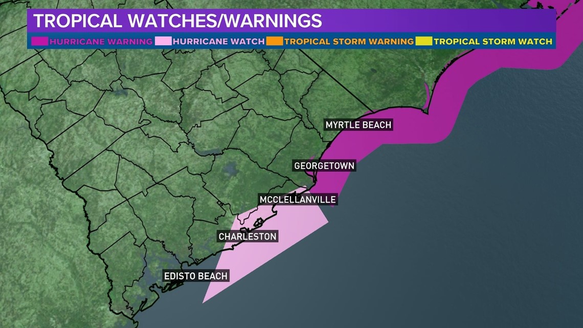
Watches/Warnings for South Carolina
A Storm Surge Warning has been issued from South Santee River, South Carolina, to Duck, North Carolina, and the Albemarle and Pamlico Sounds, including the Neuse and Pamlico Rivers.
A Storm Surge Watch has been issued from Edisto Beach to South Santee River, South Carolina
and North of Duck North Carolina to the North Carolina/Virginia border.
A Hurricane Warning has been issued from South Santee River, South Carolina, to Duck, North Carolina, and the Albemarle and Pamlico Sounds.
A Hurricane Watch has been issued from Edisto Beach to South Santee River, South Carolina.
A Tropical Storm Warning is in effect for North of Duck, North Carolina to the North Carolina/Virginia border.
A Tropical Storm Watch has been issued from north of the North Carolina/Virginia border to Cape Charles Light, Virginia, and for the Chesapeake Bay south of New Point Comfort.
What is a hurricane warning? A hurricane warning indicates that hurricane conditions (sustained winds of 74 mph or higher) are expected somewhere within the specified area.
A Hurricane Warning means that hurricane conditions are expected somewhere within the warning area. A warning is typically issued 36 hours before the anticipated first occurrence of tropical-storm-
force winds, conditions that make outside preparations difficult or dangerous. Preparations to protect life and property should be rushed to completion.
A Storm Surge Warning means there is a danger of life-threatening inundation, from rising water moving inland from the coastline, during the next 36 hours in the indicated locations.

Florence is expected to produce heavy and excessive rainfall in South Carolina with up to 5 - 10 inches, and up to 20 inches in isolated areas. This rainfall would produce catastrophic flash flooding and
significant river flooding.
Evacuations Ordered Along the Coast
Gov. Henry McMaster has ordered evacuations along the coast. Those went effect Tuesday. More than a million people will be affected.
Related Coverage: SC Gov. Henry McMaster Orders Evacuation of Coast
What Should I Do Now/Should I Be Worried?
As we said, it's too early to tell what Florence will do. But it is the most likely scenario that the storm will significantly impact the Carolinas.
For now, the best thing to do is just make sure you're staying informed. You need to review your hurricane plan, and check up on any of your supplies that you might need, such as batteries and flashlights. Keep up to date by reading the forecast articles here on our website or app, and we'll of course have regular updates in all of our newscasts.
Stay Connected/Download the WLTX App
You can also review the South Carolina Emergency Management Division's checklist for preparation. Again, no need to panic and run out and buy things at the grocery store. But it's just good to go ahead and look at it. There are a ton of good resources there.